


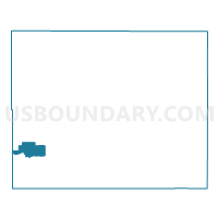
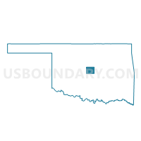
Voting District 489, Oklahoma County, Oklahoma
About
Outline

Summary
| Unique Area Identifier | 654587 |
| Name | Voting District 489 |
| County | Oklahoma County |
| State | Oklahoma |
| Area (square miles) | 7.22 |
| Land Area (square miles) | 7.21 |
| Water Area (square miles) | 0.01 |
| % of Land Area | 99.92 |
| % of Water Area | 0.08 |
| Latitude of the Internal Point | 35.46307290 |
| Longtitude of the Internal Point | -97.61980590 |
Maps

Graphs
Select a template below for downloading or customizing gragh for Voting District 489, Oklahoma County, Oklahoma


Neighbors
Neighoring Voting District (by Name) Neighboring Voting District on the Map
- Voting District 462, Oklahoma County, OK
- Voting District 464, Oklahoma County, OK
- Voting District 466, Oklahoma County, OK
- Voting District 469, Oklahoma County, OK
- Voting District 488, Oklahoma County, OK
- Voting District 490, Oklahoma County, OK
- Voting District 491, Oklahoma County, OK
- Voting District 493, Oklahoma County, OK
- Voting District 494, Oklahoma County, OK
Top 10 Neighboring County Subdivision (by Population) Neighboring County Subdivision on the Map
Top 10 Neighboring Place (by Population) Neighboring Place on the Map
Top 10 Neighboring Unified School District (by Population) Neighboring Unified School District on the Map
- Oklahoma City Public Schools, OK (285,940)
- Putnam City Public Schools, OK (119,728)
- Western Heights Public Schools, OK (15,386)
Top 10 Neighboring State Legislative District Lower Chamber (by Population) Neighboring State Legislative District Lower Chamber on the Map
- State House District 89, OK (36,420)
- State House District 84, OK (34,376)
- State House District 90, OK (31,669)
Top 10 Neighboring State Legislative District Upper Chamber (by Population) Neighboring State Legislative District Upper Chamber on the Map
- State Senate District 22, OK (98,783)
- State Senate District 45, OK (85,350)
- State Senate District 46, OK (71,941)
- State Senate District 40, OK (71,882)
- State Senate District 30, OK (71,145)
Top 10 Neighboring 111th Congressional District (by Population) Neighboring 111th Congressional District on the Map
Top 10 Neighboring Census Tract (by Population) Neighboring Census Tract on the Map
- Census Tract 1069.15, Oklahoma County, OK (6,097)
- Census Tract 1056, Oklahoma County, OK (5,182)
- Census Tract 1059.07, Oklahoma County, OK (4,152)
- Census Tract 1069.13, Oklahoma County, OK (3,904)
- Census Tract 1069.14, Oklahoma County, OK (3,717)
- Census Tract 1069.12, Oklahoma County, OK (2,940)
- Census Tract 1086.01, Oklahoma County, OK (2,214)
- Census Tract 1070.02, Oklahoma County, OK (1,918)
- Census Tract 1069.09, Oklahoma County, OK (1,516)
- Census Tract 1086.02, Oklahoma County, OK (935)